
Betting Best on Baldy

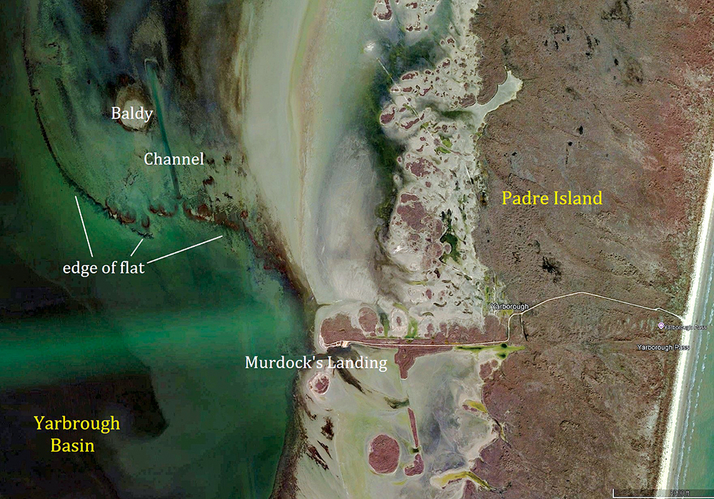
Southeast of Baffin Bay, in the Upper Laguna Madre, in central parts of the area generally known these days as Yarbrough, an old sand bar covered by super shallow water lies adjacent to a silty gut. People refer to this circular crown of bright sand as Baldy. I and many others use the moniker more broadly, to refer to the entire expanse of flats lying on the north side of a curving, sandy edge running west from where Yarbrough Pass once connected the waters of the Gulf with those of the lagoon.
The history of the events which helped form the topography of this famous fishing hole date back nearly a century to the 1930s, when hypersalinity regularly caused problems for the marine organisms which reside in this estuary. "In the summer of 1938, millions of fish perished in the southern parts of the Upper Laguna Madre. State officials believed the high salinity of the water in the area likely caused the catastrophe, and they proposed dredging a pass to connect the waters of the lagoon with those of the Gulf, to allow the less salty ocean water to dilute the bay water.
Yarborough Pass was dredged by the Pure Oil Company in 1941, at a spot then known as Murdock's Landing. The channel was named for W.O. Yarborough, a former member of the Texas Game, Fish, and Oyster Commission, in recognition of his work. Over the next several years, sand filled it up repeatedly, forcing the pass to be dredged again and again. By 1950, the state gave up on dredging the pass and let nature reclaim it." (stxmaps.com, 2026)
Concurrent with these events, the Pure Oil company dredged several channels inside the ULM, one of which bears the name of the company; it connects the Intracoastal Waterway with a boat shed on the King Ranch Shoreline. They also cut ditches in South Yarbrough and just west of the pass, in the process creating the shiny spot with the famous name, which I and many others still call Baldy to this day.
The state officials who decided to create a connection between the ULM and the Gulf definitely did so in an attempt to improve the health of the fishery. I doubt the same is true for the Pure Oil Company. Most likely, their dredging efforts focused on making more areas accessible to boats and people. Inadvertently, though, the channels they dug all those years ago and the spoils they created adjacent to those channels by dumping the material they dug out of the bottom did create niche habitats which big, speckled trout use to survive and thrive.
The basic features of the Yarbrough area include a relatively deep basin with a hard sandy bottom, a series of rocky, grassy spoils lying on the east side of the Intracoastal, and generous expanses of soft, grassy flats covered by shallow water. In this place, numerous spots provide fish access to potholes and grass edges in skinny water without requiring them to travel far from the deeper waters of the basin. In hot weather, I like targeting trout in places with lots of microspots like these, with shallow feeding stations lying really close to deep water.
Baldy and the flats surrounding it definitely provide trout, redfish and flounder good places to find the food they need. I'm neither a hydrologist nor a marine scientist, but one thing about the basic layout of the area around Baldy seems clear to me. The dredging of Yarbrough Pass helped shape and define the flats north and west of the location where the water from the Gulf entered the Laguna Madre. Undoubtedly, water flowing from the ocean into the lagoon carried sediments; the prevailing onshore breezes likely blew those sediments to the north and west, where they settled to the bottom and created the curving sand bar anyone can see on a decent satellite image of the area.
This edge, comprised mostly of hard, sandy humps covered with grass, starts just north and west of Murdock's Landing and continues for about a mile and a quarter in basically a northwesterly direction, before turning more toward due north. The aforementioned channel dredged by the Pure Oil Company cuts through the edge about three quarters of a mile from Murdock's Point, extending for over half a mile into the flats north of the edge. The eastern edge of the bright sand spot which lends its name to the place lies less than 100 yards to the west of the channel. All these features accentuate the potential for catching big trout in the area, because they provide numerous places where the predators can find food in shallow water without venturing far from the comfort of the depths.
I've caught some big trout on Baldy Flats during the summer heat wave. I caught all the fish I weighed during the 2001 Troutmasters Classic in a long, slender, natural gut surrounded by grass beds lying west of Baldy, placing in the top ten in the event. I'd have finished at or near the top of the leader board if I'd landed the biggest trout I hooked that July weekend. She came fully out of the water taking a frog-colored Super Spook while thunder rumbled out of a distant summer squall darkening the skies over the Gulf, to the east of where I stood. After a long fight, my line brushed against barnacles growing on a short stick used to mark the spot and broke. I'll never know the dimensions of the fish; she appeared much larger than almost any I've caught on many visits to the place in the years since then.
I caught my largest trout on these flats on the last day of March 2015. We'd stopped in the area after fishing farther south for most of the morning. With a steady, moderate southeast wind on our backs, we jumped out of the boat along the edge of one of the grassy humps framing the flats, and I caught a trout weighing about four pounds on a MirrOlure Provoker dangling under a cork. A brown algae bloom stained the water everywhere in the lagoon and Baffin during those days, and I'd been using the cork and jig regularly, to cope with the minimal levels of visibility.
After one of my customers caught a trout similar to mine, I noticed lots of frantic mullet leaping on the mooshy flat closer to Baldy, so I told the guys to keep throwing in the vicinity of where we'd earned the two bites and headed into the shallows. The first bite I earned up there came from a 30-inch trout. I waved the guys over and soon after they joined me, I caught a 10-pound fish which stretched the tape to well over 31 inches. The following day, I and a customer caught two more memorable trout, both 30-inchers.
On those two days, an extremely low tide created a scenario which enhanced our chances of catching some of the biggest trout in the area. Low tides force fish out of the vast acres of shallow water lying north and east of Baldy. Folks who regularly burn those flats see small pods of giant trout roaming around when tide levels run higher. Low tides can and do force those trout to the edges of the shallows, to places like Baldy Flats.
Anglers who aren't familiar with the natural dynamics driving the tides in a place like the Upper Laguna Madre might miscalculate these things, if they use their experiences in other places to guess at tide levels. Many Upper and Middle Coast anglers in the Lone Star State know onshore winds push water into their bays. But in deep South Texas, in the Upper Laguna Madre, strong onshore winds blow water out of the bay, unless they're oriented almost due east. Warm, windy spring weather pushes water off the shallowest flats surrounding the Yarbrough Basin, sending some of the biggest trout in the state to places where wading anglers stand a decent chance of catching them.
Consistently, for me, betting best on Baldy means visiting the place when tide levels run low and water temperatures range between about 60 and 85F. As is the case with most other places I've fished, I've caught almost all my really big trout in some of the shallowest parts of the area, often in depths measuring less than two feet. Fishing for monster trout in such depths in places like these often means tolerating hordes of aggressive redfish, which typically outnumber the trout and make catching them more difficult. This feels like a hassle mostly to trout snobs like me; for many other folks, catching plenty of reds while fishing in a way which can produce a trophy trout or two is about as good as it gets.
I've found the fishing for big trout better on the flats west of the channel lying beside Baldy, though I have caught some memorable specks on the flats east of the channel too. I've also caught a decent number of picture-worthy trout on the outside slopes of some of the hard, grassy humps framing the flats, usually while mild winds of moderate speeds blow at them during the spring months. By the time the summer heat wave hits full stride, fishing out around the edge of the flat and/or throwing lures into the depths outside the edge usually results in bites from under-sized and keeper trout.
Certainly, anglers targeting numbers of regular-sized trout can make plenty of hay in this place during the dog days. I vividly recall many hot days on which we caught 100 or more trout throwing small topwaters and soft plastics around the grass beds west of Baldy. On the other hand, I have little experience fishing this area in cold weather. I've never thought of it as having prime potential soon after cold snaps, because no land mass protects these flats from the chilling effects of strong north and northwest winds. Other folks might know something I don't.
I do find it fascinating to trace the history of this remote area, how it came to look the way it looks. Ironically, state officials dredged Yarbrough Pass the year my father was born. He's gone now, as is Yarbrough Pass, both erased by the relentless sands of time. But Baldy and its associated flats persist, holding up well over all these years, still offering the anglers who venture down this way a chance to encounter some of the trout which represent the legacy of a famed fishery.