

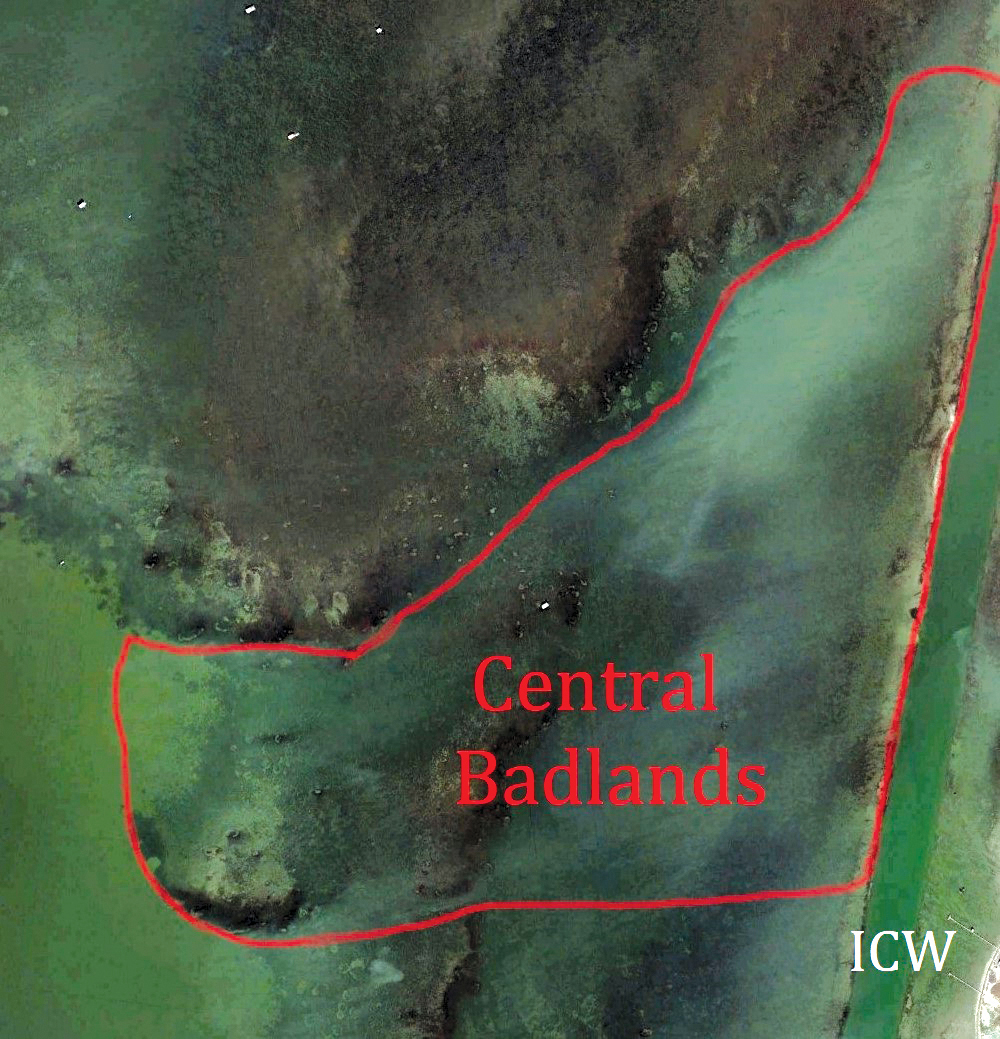
Breaking Down the Central Badlands
Because the Badlands sits at the intersection of Baffin Bay and the Upper Laguna Madre, two of the most productive big-trout fisheries in Texas, the area offers real opportunities to catch the trout of a lifetime. Significantly, the water in this place has variable depths, parts of the area hold up well under strong winds of two primary directions, and four different constituents cover the bottom here. These factors enhance the potential for the Badlands to consistently produce fish for lure chunkers who can safely access the many microspots present in such a legitimately famous place.
I and my friends and clients have caught plenty of memorable monsters in the Central Badlands, one of the most picturesque places a wading angler can target giant trout in the Lone Star State. Replete with targets comprised primarily of rock faces, grass seams, and silty potholes, central parts of the Badlands stir the hearts and souls of folks fascinated with the visual aspects of lure fishing. With a generally soft bottom and plenty of thick grass beds, this area isn't particularly easy to wade, and at times, wading is impossible in some of its deeper sections.
On its eastern edge, a shallow sandbar lying adjacent to the Intracoastal Waterway makes entering the Central Badlands a challenge for most boaters, especially when tide levels run low. To the west of this sandbar lies a silty hole where numerous serpulid rocks reach through the bottom and nearly touch the water's surface. In its northeastern extremes, this hole narrows into a gut lying between the bar next to the Intracoastal and the shallow eastern edge of the Badlands Crown.
Rocks and grass beds in shallow water shape the meandering northern fringe of the Central Badlands, and a gut runs generally west to east into the middle portions of the area, connecting it with deeper waters in the Baffin Bay Basin lying west of the place. This gut is widest in the west, where it slopes off into the basin, and narrowest in its eastern portions, where it funnels through a maze of rocks and empties into the silty hole. South of the narrower part of this funneling gut, a shallow field of soft grass beds, mud, and serpulid rocks comprise an area some call Hell's Half Acre.
This entire area, more than any other, strikes me as a paradise for lure chunkers who love casting at targets. In all its parts, given water of even decent clarity, an angler can cast at numerous fishy-looking microspots without moving around much at all. In many parts of the place, potholes with silty bottoms lie close to rocks; big trout lurk in them, waiting to ambush their prey. These predators also sometimes like sitting on top of the rocks, showing stubborn resistance to moving off them to strike, so anglers bent on making them bite must pull their lures right over the rocks. Most of the big trout caught in this famous part of one of the world's premier trophy fisheries bite lures passing close to the boulders which provide the genesis for its two-faced reputation.
Using conventional floating plugs and floating Paul Brown lures makes the task of fishing around the rocks easier and more effective. Standing in the silty hole and casting topwaters and/or slow-sinking twitchbaits toward and/or beyond the rocks lying on the southern edge of the Badlands Crown proves effective, especially when relatively light onshore winds facilitate the ease of working this pattern. Big trout can, of course, also be caught well away from rocks in the Central Badlands.
On a sinking Paul Brown Fat Boy, I caught the trout in the picture included with this article in the stretch of water where the gut funnels down and dumps into the hole. The contours of the grass beds and potholes created a deliciously enticing scene in the place that day, a visual source of motivation for any lure chunker with serious intentions. The big fish bit as my lure walked across a dark grass bed the size of my boat, then entered a bright pothole. The subsequent battle I won helped the Central Badlands move into one of the prime spaces housing my most cherished memories.
In cold weather, with north winds blowing, standing on the southern edge of the Crown and casting into the deeper waters of the silty hole or the gut running west into the basin makes good sense. Particularly in the first half of winter, big trout retreat into the depths of the hole and/or the gut when water temperatures decline after the passage of a front. On one such occasion, nearly a quarter of a century ago during the first month of the year, I caught my first thirty-inch trout using these tactics.
Before a cold front passed, we walked from west to east along the southern fringe of the Crown, casting to the south into the deeper waters of the gut in dead-calm conditions. On topwaters, we caught small and medium-sized trout, up to about eighteen inches. They struck reluctantly, almost sheepishly. But as the front passed over the coast, spawning a light, crisp northerly breeze, bigger fish began tackling our lures as if their lives depended on eating them. For about an hour, before the light north wind increased and began to howl like an angry Old Man Winter, we caught several trout weighing between seven and about nine pounds, including the thirty-incher.
Sometimes, after such an event, the trout living in this area apparently retreat into water of greater depths, like the basin lying west of the Central Badlands. In situations like those, numbers of trout, including some really big ones, sometimes use the gut to move back into places where they can prowl around the rocks and grass beds near them, looking for easy meals once conditions moderate somewhat. This can happen a couple of days after a frontal passage, as the light fades at the end of a sunny winter day. Then, in the gloaming, the anticipation of big bites creates a palpable sense of enchantment in a place cherished by all of us who've chased monster specks here.
Just south of the widest part of the gut connecting the Baffin Bay Basin with inner portions of the Central Badlands, a semi-circular formation of large rocks frames the edge of a mooshy flat normally covered by water less than knee-deep. Certainly, a patient angler properly wielding floating or slow-sinking plugs could pull a world-class trout off these rocks at any time of year, particularly during relatively calm lulls in the spring and fall and during a warming trend following a frontal passage in winter. Like other parts of the Central Badlands, this rocky hump provides numerous enticing targets with potential to hold trophy trout.
Over a quarter of a century, I've learned much about catching fish here, and also about the hazards of navigating in the Badlands, mostly by enhancing my GPS with skulls marking many of the rocks left off the maps which come with the devices. I've located some of these using Google Earth, setting the software to historical images taken while the water ran really clear, and also by spotting and marking them while idling through dangerous areas in conditions which allowed me to see into the water easily. I've also found some with the skeg of my motor.
In one instance, I bumped into a small boulder lying just a few feet to the side of one of my tracks. That day, I couldn't see the rock, though I could have read the label on a beer can lying on the bottom. Some of the rocks in this region blend in with the bottom like chameleons blend in with the bark on a tree. These facts help preserve my appropriate and necessary fear of navigating in and around the aptly named Badlands.
Certainly, less-experienced boaters should be aware of the dangers inherent to operating within the boundaries of this notorious area. No current GPS map system shows all the rocks present here, and some of the omitted ones project from the bottom in places which can wreak havoc with captains who think they're proceeding with ample caution. In one case, a large formation of rocks appears on the main map, accurately located. But the makers of the map failed to mark a single large rock lying near the northern edge of the formation.
A captain trying to access the deep gut funneling into the Central Badlands might decide to swing around the formation, then idle over to the edge of the gut to get out of the boat and start a wade. If said captain left a reasonable amount of space between his bow and the edge of the rocks marked by a red line on the screen, he might also run right over the unmarked boulder. This is but one of the many potentially treacherous scenes in which careless people who venture into this place might find themselves.
The dangers associated with fishing in the Central Badlands don't end once the spike sticks into the bottom and holds the boat in place. Waders also face issues while working through some parts of the area. When tides run in the medium to high range, stepping into a soupy pothole and filling the waders becomes a real possibility. Doing so in cold water can precipitate disaster, especially if the mishap occurs far from the relative safety of the boat.
People who regularly find success fishing here do so after studying all the resources available to them and after upgrading the data in their GPS maps. They put in time to learn the subtleties of the layout of this complex, expansive, and enchanting place. Then, they're able to develop strategies to safely and effectively target the monster trout which reign as the metaphorical royal family in this rightly revered region.